Warning - information presented here is contributed by users and has not been verified or evaluated for accuracy or safety. Use caution and proceed at your own risk!
A kid friendly, single track trail that winds along the Bella Coola River. High bear use in area in bear season. Please be respectful of private property in the area.
This trail leads to the site of an old forest fire lookout so you can bet the view is panoramic. The trail starts along the main logging road for about 300 m then veers left onto a branch road. Follow this for another 300m to the top of the hill and across the flats. Then follow ribbons to the right as a smaller road eventually turns into a trail near a small creek. The trail climbs steadily from here through second growth forest, some of which has been juvenile spaced. Eventually the trail enters an old growth forest with some large Douglas-fir. The trail veers left and then switches back and forth up to a cliff, along its base and then out on to the old forest fire lookout site. Only the cement footings remain as the building burnt down many years ago. Evidence of the telephone line can still be seen along the trail though. There is much to see from this spot named after a local painter, Carl Medby, who painted from here in the 30’s. There are excellent views of the lower Bella Coola valley looking west towards Hagensborg and Bella Coola\, north into the Saloompt River valley and south into the Nusatsum River valley.
This trail begins by following the Schoolhouse Mountain Falls trail to the west falls. At the point where the west falls trail heads up hill the loop trail veers westward slightly downhill to a ford crossing of the creek. If the water is too high this crossing may be difficult and you may need to return the way you came. Beyond the creek, the trail follows an old logging road. The mixed deciduous and coniferous forest here is second growth. This road carries on to the pit that was used to quarry granite for the highway and river diking material. Once at the quarry you can walk the road about 1km out to the highway and the bridge across Nooklikonnik Creek. Stop here for a fabulous view of Mount Saugstad to the south or during late July and early August stop here to watch the Chum or Dog salmon spawning. The rest of the loop is along the highway back to the school. Walk well off the road\, facing traffic.
Private land issues and Highway’s road to rock pit
This trail system provides an interesting walk as it offers a variety of natural sights and historic features. The first trail branches off to the left to an ancient grove of culturally modified cedar trees. This area requires respect not only for the forest but also for the First Nations people that used this area for acquiring bark and lumber from these sacred and special ‘trees of life’. Look for the distinct scars left after planks were cut and split away from the living tree. This grove also features huge cottonwood, Sitka spruce and Douglas maple. Back to on the main trail, carry on past the cottonwood grove through second growth to the rodeo grounds, hike through the cottonwood grove or loop back along the beaver pond to the road and the parking area. A variety of water fowl can be seen at the pond and look for beaver gnawing signs on shoreline trees. These trails are for hiking or biking.
Potential for interpretive trail – CMT, old/new forest,
This trail and boardwalk wind through alpine forest along Grey Jay Lake and then wanders through open meadows and wetlands to end at a viewpoint overlooking North and South Bentinck Arms. It offers a nice afternoon stroll and on return there is the option for a refreshing swim in Blue Jay Lake. Views of the Coast Mountains are spectacular, although somewhat limited compared to the ridge above M Gurr Lake. Alpine flowers are abundant in the summer. Blue Jay Lake is much warmer than M Gurr Lake and, uniquely, this high elevation lake contains trout.
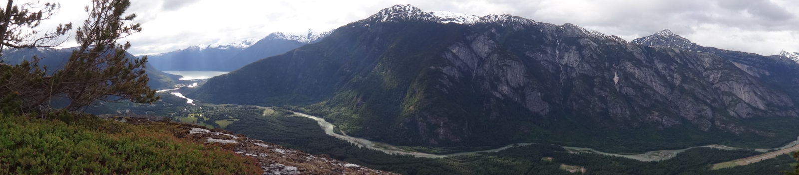
This trail winds uphill through old growth forest to a small lake and great view spots looking over the valley and mountains to the south. The trail begins in second growth forest but quickly climbs up a rocky slope into a peaceful moss carpeted old growth Douglas fir forest. Lost Lake is quite small, but the views from the trail end are rewarding. The two lookouts here offer a great picture of the glaciated u-shaped valleys of the lower Bella Coola and Nusatsum Rivers. The first lookout is to the right of the lake and the second one is beyond the lake on a trail that leads slightly downhill. At the first lookout you can easily identify Hagensborg and the airport. Look a little closer and you may even see the Augsburg Church. At the second lookout\, the view to the south is the Nusatsum valley with its regenerated logging areas and the road to Odegaard Falls. In the foreground, Nusatsum Mountain is on the left and Schoolhouse Mountain on the right. Looking out over the Bella Coola River to the east, you can see the edge of Tweedsmuir Provincial Park beyond the small community of Firvale.
Very popular. This is an interpretive trail with unique forest features and valley bottom ecosystems. There are three different trails within this park. Each has its own special features. There is an ancient forest stand with massive Douglas-fir, cedar and spruce intermingled with hemlock, cottonwood, alder and maple. There are eagle nests, bear scratch trees, fast growing second growth forest, an old homestead site, springboard logging stumps and lots of lush temperate rainforest undergrowth. A side channel of the Bella Coola River flows along the south side of the park. Once back out to the road, walk to the bridge over the Salloomt River. This a great place to see salmon spawning during August and September.
These trails offer a moderately strenuous uphill effort to the tall, cascading falls. The first part of the trail goes through a unique and interesting forest swamp ecosystem and the trail is elevated on a pleasant 250 m long boardwalk. The west falls trail veers right and the east falls trail goes to the left. The trails are identifiable by ribbon and use. At the end of both trails, are great views of the Hagensborg area, lower Bella Coola Valley, the massive granite faces on the opposite side of the valley, including Saloomt Peak and Salloompt River valley opposite right, Mill Creek opposite left and Four Mile Ridge above the airport. The east trail is somewhat steeper and cruder but the falls are more impressive than the west falls. You can edge out at the bottom of the falls and this is a great finish if you do want to carry on and scale the steep rock near the top of the falls. The West Falls trail is a mixed difficulty trail with easy sections and a steeper climb at the end. The falls at the end of the trail is a series of small cascades.
Private land issues.
With a great shoreline picnic site and a viewing platform of the falls cascading through a canyon of cliffs scoured smooth by water and glacial action, the Clayton Falls Recreation Site is one of the most popular sights in the valley. Depending on the season or the current weather, the falls can be a full apron or narrow streamlets flowing through ancient grooves. Pink salmon spawn at the bottom of the falls between late July and September. Look for them attempting to jump up the falls. Salmon also use the spawning grounds created by B.C. Hydro below the outflow from the generating station. The park has picnic tables and outhouses. At low tide there is even a small stretch of sandy beach. Watch the boats coming and going and maybe even a sailboarder, yacht or ferry. Note the old cannery across North Bentinck Arm. Seals hang out at the mouth of the creek and from the bridge over the creek you can sometimes see seals chasing down salmon at high tide.
ATV parking at water tower and BC Hydro may put in off-loading ramp
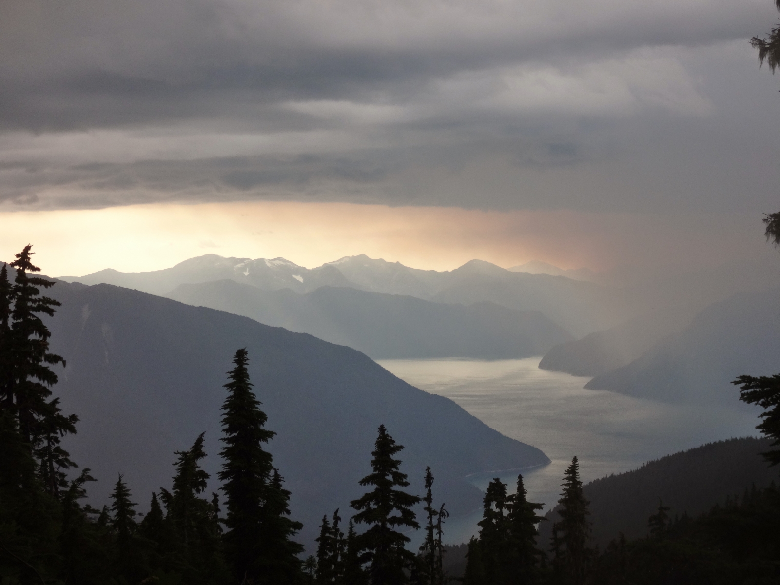
This is an easy access trail that winds through stunted sub-alpine forest to a crystal clear\, emerald jewel alpine lake. You may want to go for a quick swim, although the neighbouring pond east of the lake is warmer. Wildflowers are abundant and provide a colourful bloom in July and August. Beyond the lake the trail is not as distinct\, but still easy to follow. Once on the rocky part of the ridge\, pick your own way to the highest point. The viewpoint above the lake) provides awesome views of the coast mountain peaks rimming North and South Bentinck Arms, Burke Channel and the upper Clayton Falls Valley.